Avignon – Pont des Tourradons – Vidourle – Villeneuve-lès-Maguelone – Frontignan
The time had come to leave Avignon and with a long day ahead of us, and no locks nearby, we braved an early, 7 am start. It was still quite hot, but the wind forecast seemed manageable, so bidding farewell to this amazing city, Catharina Elisabeth cruised past this historic site once more,

and set off to tackle the last part of the Rhône that we would use, before swinging off onto Le Petit Rhône.

The Petit Rhône is a little over 60 km long, branching off near Arles, and flowing south-west through the Camargue region, before discharging into the Mediterranean Sea. We would not be cruising all that way as we would shortly turn off and join the Canal de la Rhône à Sète, our first canal for this season.

There is a single lock (Saint Giles) separating the Petit Rhône from the Canal du Rhône à Sète. I called ahead to announce ourselves, and when the gates opened, we made our way in. I got a rope on, ready to roll. The éclusière asked us to make sure we were both wearing life jackets and gave us a number of other instructions – this replicated what happened at the first of our Rhône locks, because this was the first lock before the Rhône coming in the other direction. I always wear mine as I am out on deck, but Ian complied, the gates closed, and then the gates at the far end opened almost immediately. If there was a depth change, it was very difficult to tell. Not sure why a life jacket was necessary for the helm, safe in the wheelhouse, but we do as we are instructed (if they are around to see).
It was a little strange to find ourselves on a much narrower and considerably shallower stretch of water. It had been quite some time since we had been on a canal. This one was rather unassuming at first, certainly flat (no locks), and pretty devoid of trees for the most part. With the grey, windy conditions, this first stretch was not very appealing. Given the threatening storm, we were keen to find somewhere to hole up for the night. Today had been a very long cruise of some 75 km, so we were ready to pause. The first place we checked out was a smallish mooring, Pont de Franqueveaux, but it was plainly taken up with summer ‘residents’, complete with a hammock strung up between some trees – definitely no room for the likes of us.
A little further on, we came to Gallician, which was fully occupied with cruiser-sized boats, stern onto the bank, and bows tied to poles standing in the water. I spotted a space, somewhat overgrown with cracked concrete blocks, but there were a couple of bollards, so it was ropes on – assisted by a passerby because the strong wind was blowing us away from the mooring. The space was labelled as restricted to hotel barges; and while it was quite shabby, it held the threat that if a hotel barge arrived, we would be forced off.
Pont des Tourradons
I started to prepare dinner while Ian got one of the bikes off and cycled a couple of km further along the canal to see if there was space at the next possible mooring, Pont des Tourradons. He soon called to say there was room and get ready to move. He raced back, bike on, ropes off, and we soon arrived at a delightful long, well-faced mooring with only a cruiser ahead of us. The bollards were rather far apart, but manageable.

During the early evening, a hire boat showed up and disgorged a family who appeared to be taking a picnic back along the canal, the way we had come. As it had been a long cruise, and the weather forecast was for high winds, we decided not to cruise the next day. In the morning, we trotted off to explore and found our first view of the pink flamingoes that populate this region. They were some distance away in one of the salt marshes that bound the canal on both sides, but it was still exciting.

Over the next week or so, we saw so many feeding quietly so close to our boat, and every evening they would fly over the canal to their nightly roosting place. It remained a highlight of our travels in this region. In the foreground of this, our first encounter with the flamingoes, there was a somewhat incongruous display of beer bottles neatly lined up on the old overflow gate between the canal and the étang (the salt marsh). Perhaps they were surplus to needs for last night’s family?

During the day, we took a walk in the opposite direction, along the tow path to the bridge, Pont des Tourradons, and spotted an unusual (to us) sight of hundreds of small snails climbing up fence posts, signs, tall blades of grass – all bunched up together. I am not sure what attracts them, but this was something we came across more than once as we travelled.

A couple of hotel boats passed us, heading towards Gallician, but the English couple on a cruiser that showed up during the day said hotel boats no longer stopped at that mooring. So we would have been OK had we stayed there.
Vidourle
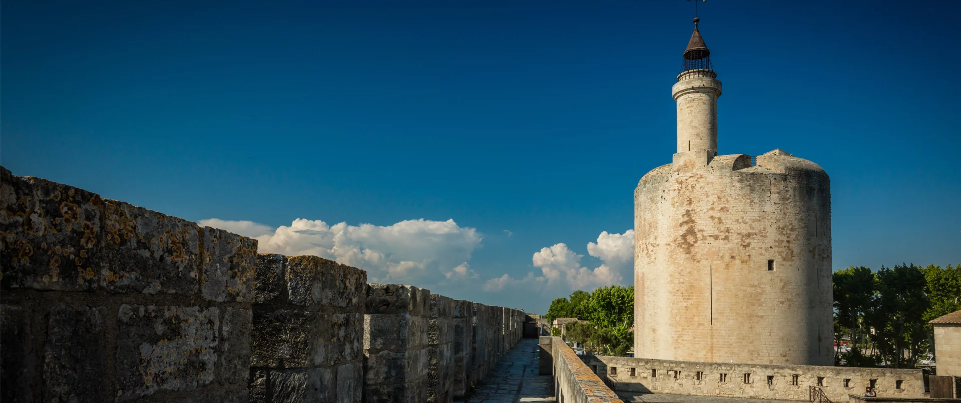
Given that the last cruise had been a long one, we did not try, or need, to go too far today, only about 11 km to Vidourle. A couple of years ago, a series of 25 m floating pontoons were fixed at helpful intervals all along this canal. As there can be limited places for a boat of our size to moor up, we found these perfect. Unfortunately, our (almost) 20 m does take up most of the pontoon, but we always try to occupy as small a space as necessary, so perhaps a small cruiser or hire boat could also use the pontoon if they showed up while we were there.
The intriguing thing about the Vidourle River, across which the canal passes, is the massive gates that can be dropped to close off the canal if the river floods. Rising high above the canal, the Portes de Vidourle are quite an imposing feature. The river flows between these gates from right to left in the photo below.

We passed comfortably through, and just beyond the second gate, we saw one of the canal’s pontoons unoccupied and took up our spot.

Aigues-Mortes
We wanted to take a side trip to Aigues-Mortes, and this would be the closest we would be able to get to the historic coastal town. I had previously contacted the port there, but as soon as they learnt our length, there was a very firm, uncompromising, “non”. We were getting used to places refusing us entry ostensibly due to our size. However, when you see these places, there are plenty of bigger barges, but they do seem to be more permanent, or at least, summer moorings. One can turn off the canal a few kilometres before the guard lock and take a separate route to Aigues-Mortes, but we understand this is mostly used by commercial vessels, and in the absence of suitable mooring spots, a bit pointless for us. So we settled in, got the bikes off and set off the 5 km or so to see this ancient fortified town for ourselves.


The Port de Plaisance, Aigues-Mortes, with the walls of the fortified city in the background.No big deal on a bike, right? Wrong! Almost all of the journey was sliding around on a path of sharp, white, chalky stones, which I was certain were going to rip my leg open if I fell off my bike. There were two possible routes from the canal to Aigues-Mortes, and we had chosen the one that followed the Vidourle River. (Sensibly, we opted for the other route for our trip back to Catharina later that afternoon.)

On the forward journey, we came across a group of the famous Camargue bulls, a protected, native breed. The group we saw had protective covers on their horns and cow bells around their necks. We heard them long before we saw them. They are bred mainly for the course camarguaise, a bloodless bullfighting game. The bulls are not injured or killed; the focus being on the skill of the human competitors, whose aim is to remove a ribbon tied to the horns during the spectacle of the game.

It all started with salt
Aigues-Mortes means “dead or stagnant waters” in the local Occitan language, originating from the Latin Aquae Mortuae. The name refers to the stagnant marshes, lagoons, and slow-moving water surrounding this medieval fortified town in the Camargue region of southern France.

As a trade item, salt was as valuable as gold. It was used as a religious offering and a currency. A landowner who possessed a salty pond was considered a rich man. From its earliest days, Aigues-Mortes was significant for its salt fields and location bordering the Mediterranean Sea. The area may have been established as early as the 5th-century, with the Benedictine monks of the Abbey of Psalmody ruling the region. The locals lived in reed huts and made their living from fishing, hunting, and salt production from several small salt marshes along the sea shore.

In the 13th century, Aigues-Mortes’ salt fields and the proximity to the sea appealed to King Louis IX. In 1224, near to death, made a vow to leave on Crusade if God restored him to health. He recovered and in 1241, intent on creating a passageway for trade and for his crusades, he turned his attention to the spit of land in the marshes. He obtained the town and surrounding lands by exchange of properties with the monks of the Abbey, and work began to build a port to ensure strategic access to the Mediterranean Sea.
Aigues-Mortes was the point of departure for two Crusades; the VIIth and the VIIIth. St. Louis was captured during the first of these crusades, and in the second he died from dysentery in Tunis. in 1270. The ‘St. Louis’ moniker originally confused me as neither of these Crusades appeared to be particularly successful, but in fact he was canonised in 1297 due to his reputation for piety, charity to the poor, and his leadership in the Crusades. The only French monarch to be canonized as a saint in the Catholic Church. Sadly, he did not see the completion of the fortified city, which was not fully realised until 1295.
Entering through one of the gates, we were relieved to see that, decently clothed, we met the dress standards required of this mediaeval fortress.

To get a break from the heat and sun, (not complaining) we took a stroll through the church of Notre-Dame des Sablons, nestled within the fortess walls. Built in 1246 this historic gem once served as a place of prayer for crusaders before their departure for the Holy Land under the reign of Saint Louis. After the tower collapsed in 1634, it was not used for a hundred years. Following several transformations, the church was fully restored in the 19th century. The main alter and choir stela (loosely, the stone supports) originating from the old Abbey of Psalmody, are still in place. As befits a well-off tourist town, the interior was immaculate.

The plaque shown below translates as: “To the memory of St. Louis and his knights who received the cross in this church from the hands of the Cardinal legates, (named) for the 7th Crusade 25 August 1248 and the 8th 1st July 1270. God wills it. Aigues-Mortes grateful to his royal founder will forever bless the immortal memory.”

Delighted to find a statue of Jeanne d’Arc, captured in the same frame as one of St. Louis.

The fortress consists of 1,634 metres of ramparts flanked by twenty towers. We bought tickets that gave us access to the ramparts in addition to the comprehensive historical displays within the fort itself.
Firstly, though, was lunch in the main square, having run the gauntlet of tourist shops that line the paths to the centre. My burger included the usual suspects, but was pimped up with the addition of a hash brown and a slab of raclette cheese, wrapped in prosciutto. Frites and salad completed the offering and ensured I would not be looking for dinner once we were back on Catharina. The 500 ml beer is a given on these hot days.

A good walk, climb and trek around almost 2 km of ramparts should help digest that.
Another feature of the town was the profligate variety of ice cream shops – this excess allowed Ian to find, and consume, amarena icecreams from three locations, further distancing us from the need for an evening meal.

Entering the fortifications of the city, one of the first rooms we entered had a comprehensive audio visual display, which was only given in French, but interesting as far as I could follow it.
Aigues-Mortes was a major port frequented by Italian merchants, who established trade routes along the Mediterranean. Following Louis’ death, his son, Philippe the Bold, managed to impose the Kingdom’s sole and unique access for maritime trade in goods. The Crusades had brought spices and silks back to the West, with pepper and ginger becoming a currency for exchanges. Spices were expensive and were reused in medicinal preparations after their use in cooking, their therapeutic properties well known.

The Constance Tower, or King’s Tower
Built on marshy ground, stabilised by a mass of wooden beams more than 20 m deep, the Constance Tower consists of two main rooms, one above the other, each 10 m in diameter, with walls 6 m thick. Originally, this was built as a defence point, where, from the turret above and lookouts could watch over the passage of ships subject to duties and taxes for crossing the King’s waters, later, King Louis’ garrison was housed in the tower.
As a result of the movement of goods, the reformist ideas of the German monk, Martin Luther, reached Aigues-Mortes and a Protestant community was formed. During the Wars of Religion, the city was granted the status of a safe haven, with a stable military presence guaranteeing the coexistence of the two faiths.
The Tower of Constance now became an ideal prison for victims of all causes, the martyr of the Huguenots being particularly well known. In 1685, Protestantism was banned. For almost 100 years, in conditions of extreme misery, this tower famously housed around 200 Protestant women who refused to renounce their religion. They were hidden away in a room deprived of air or of the light of day. One of the women was 90 years old when released and had been imprisoned for 36 years. The most famous female prisoner was Marie Durand who engraved the word “Resist” on the prison wall. Incarcerated at the age of 17, she was released 38 years later.


We continued our walk around the ramparts; having begun, there was no way down until we had completed the circuit.

All of the towers and viewpoints were well-labelled, with English translations included, making it easy to understand their designations and original uses. Each one, on its distinctive pink shield, showed its position along the ramparts, all with respect to the Constance Tower. Some of the towers were used as dwellings, some were guard rooms holding reserve troops. Displays inside the stone rooms described their original uses. There was of course, some torture and some burning at the stake. One tower, the ‘Tour des Bourgignons”, had a particularly disturbing story to tell.

During the winter of the Armagnac-Burgundian civil war in the 15th century, a troop of marauding Burgundians were killed. Their bodies were dragged inside the walls, salted, and stacked in this tower. The whole tour was excellent, lots of interesting material of all types and made a bit easier by almost all having an English translation.

It had been a long and hot, but very rewarding day and we were ready to cycle back to Catharina and relax. Choosing the second of the two possible bike routes, we came across some of the ‘wild’ white horses of the Camargue, hitched up to a cart, taking a family for a ride.

Back on board we were greeted with the cry of many, vibrantly colourful birds, identified as European Bee-Eaters, common in this area. These birds, recognizable by their turquoise, yellow, and chestnut plumage, congregate in colonies to nest in sandy riverbanks and coastal dunes, feeding on bees, wasps, and dragonflies. They darted in an out of their nests far too quickly for us to get a decent picture, but, below is an image of one.

However, we did grab footage of the water-bomber planes flying overhead. In groups of four, the planes flew over us several times that evening. We remember noting areas of the Rhône identified on our maps as places where these Canadair water bombers frequently use the river in southern France for skimming water to fight regional forest fires. These “Superscooper” planes scoop over 1,600 gallons in 12 seconds. We assume these planes had filled their tanks before flying in formation believe the fires around Narbonne were the recipients of the water.

Villeneuve-lès-Maguelone
Continuing along the canal we passed the most delightful spots that looked like little holiday homes,

and saw a couple more of those useful floating pontoons we had used before. However, our next stop was to be Villeneuve-lès-Maguelone. There was an unusual barrier ahead of us, the Pilou mobile footbridge, which crosses the canal and allows access to the Mediterranean beaches. It’s at water level and, by default, blocks the canal during the day. But for boats that want to travel along the canal, one has to sound a horn to alert the bridge keeper to one’s presence. Like clockwork, we sighted the floating bridge, sounded our horn, and a chap darted out of a little hut and started the outboard motor on the bridge, which then smoothly set off across the canal, opening up our passage to the other side. Once the boat has passed, he engages the other outboard motor and returns the bridge to its waiting position.

Operating through the day, from something like 8 am to 8 pm, it remains open after that to allow unimpeded movement of commercial barges. Anyone who finds themselves on the wrong side of the bridge after this time must make their way along the coast to the next village, or remain on the village side.
The moorings were plentiful, free (ie no facilities) and different yet again. The bank on the south side of the canal has been built up somewhat with concrete walls, from which jut concrete blocks at intervals, all faced with a long rubber fender. The idea is for the boats to space themselves between or across the concrete fingers, depending on the length of the vessel.

Bikes off as soon as possible, we crossed the floating bridge, as pedestrians this time, and explored the little village of Villeneuve-lès-Maguelone. We didn’t find much, but there was a small church with some brightly-painted statues. Saint Roch shows up quite often, always depicted with a dog and a leg wound. Unsurprisingly, he is the patron saint of dogs, invalids and plaque victims. Legend states that while dying of the plague, a dog brought him bread and licked his sores, aiding his recovery.

Cycling back to the canal, and over the bridge, we felt it was high time we had a look at the sea. A lovely path took us around another of the salt marshes, complete with flamingoes feeding right beside us.


The colourful patches on the water surface are likely mats of cyanobacteria or other halophilic microorganisms.
We left our bikes beside a little path that took us the last 100 metres. Here, there was a caravan/kiosk selling ice creams, chips and drinks. But perhaps more exciting was the guy pulling a little cart along the beach, selling ice creams to those too lazy to leave the warm sand. In the absence of any ‘Amarena’, Ian did not feel inclined to partake.

And down to the sea we went. Obviously, it was fabulous. The first day, there were heaps of youth taking canoes out, accompanied by squeals of delight as they braved the gentle waves.

We came down here several times over the few days we spent at this mooring, exploring just a little of the pristine 9 km of beach the region boasts. The water was pleasantly cool, and the only issue was the stony bottom, which made for tentative stepping in and out. For those without bikes, two little tourist trains make a repeated round trip between the canal and the sea.
Thanks to its defensive position between a salt pond and the sea, Villeneuve-lès-Maguelone was, during the Middle Ages, both a religious and a strategic site, with the surrounding plain used for agriculture and developing viticulture. In the centre of the peninsula stands the cathedral of Saint-Pierre de Maguelone (several names are given to this once-important edifice), which, despite the attention given to it by restoration, still seems to be somewhat incomplete.

The interior was devoid of furnishings, but held some funerary stones and friezes. We wandered around the somewhat neglected gardens, serenaded by a lonely peacock, and then returned to our bikes to cycle the 1 km or so to the beach.

One issue I had to face was that the unremitting heat was punishing the flowers. However, as we were cruising in saline water, I couldn’t use the canal as a source for watering them. Instead, I had to use our drinking water. Fortunately, we had topped up in Avignon, but this would have been an issue if we had planned an extended stay at the beach. Still, the flowers began to show definite signs of distress because of their rationed watering.
Another feature was the strong wind – it was calm in the early morning

but started to strengthen after sunrise, and by early afternoon, it was blowing a gale. It was coming from the north and blowing across the canal to the side where we were moored. No issue for us, but some of the many hire boats found it a bit tricky, even though, blowing in that direction, it tended to push a boat onto the mooring. One in particular had several attempts at making an approach to moor up, doing a full 360º turn and still couldn’t get close enough to get secure. Ian and a nearby Kiwi went over and managed to pull them in. Turned out it was their first day, and this small hire boat didn’t have a bow thruster. Not a necessary item if you are experienced, but for novices in a boat, a useful and, frequently, very heavily used tool to assist in navigation.
We were treated to some fabulous sunsets, but it was time to move on.

Frontignan
It was a short and not especially scenic 2-hour cruise to Frontignan. The final approach to the town involved a bit of a swerve to avoid shallows where the canal joins another that heads off towards the Med and the town of Sète. We were aware that there was a low bridge between us and our preferred mooring that generally opens twice each day, at 8:30 am and 4 pm, but in July and August also opens at 1 pm.

So we moored up near the bridge after passing what were obviously seating stands and marquees being erected, presumably for some events taking place on Bastile Day (2 days away).
A man and his elderly wife stopped to compliment us on Catharina and my flowers, but then, a short time later, came back with a small posey of lavender. How charming!

On time, the sound of bells announced the impending 1 pm raising of the bridge and, after the upstream boats passed, we cruised under the raised road then the rail bridge (which did not need opening) and took up a mooring on the seaward side.

The facilities looked excellent (power and water), and the quayside was nicely laid out with paving and seating for those who wanted to relax near the canal.

4 Responses
A fascinating blog post as always. Your photos are wonderful and the text is full of interesting information. I think I would like to visit Aigues Mortes. The Carmargues has long fascinated me with its salt flats, the flamingoes and its bulls. I think it must be very similar to the eastern Algarve in Portugal. Anyway, I am quite envious of your journey through it although I’m not sure I would enjoy the Rhône. Thanks again for taking us along on your travels! xx
Sorry, Camargues…without the ‘r’! I always get it wrong.
Val, kind words as always. We have loved every journey we have taken on Catharina Elisabeth. And while every waterway brings new challenges, it also brings the most amazing experiences. But I have to say, cruising along the south is a dream come true. This was the thought, the plan, the wish from the very start. The Rhône was not bad at all. Apart from the argument with that duc d’alb of course! We did see a very small yacht several times on the river, and they never seemed troubled at all by the river or the giant locks. Although, I was happier in our lovely barge. But the Rhône à Sète and the Midi have been glorious. Lisette
Lisette, how lovely to be fulfilling your dream! I’m really so pleased for you, and I love following your journeys here.